
The Latest Buzz
Here’s where we’ll ship Hivemapper Dashcams and turn on HONEY token rewards first

Note: Since publishing this blog post on July 7, 2022, we have made a change to how we fulfill pre-orders. Ahead of the Hivemapper Network and its HONEY token launch on November 3, 2022, we started shipping all pre-orders based on "first to order, first to ship" globally. Since the launch, contributors can earn HONEY tokens for mapping and QA reviews globally and are getting a boost in the 35 metro regions defined in this blog post. You can view activity across the 35 metro regions in the Hivemapper Explorer.
In How It Works, we describe how the Hivemapper Network will activate regions around the world in a phased approach according to a schedule. For our Mainnet Beta launch, we will activate mapping and turn on HONEY token rewards in 35 metro regions. After Mainnet Beta, we will activate token rewards globally. We’re using this phased approach to ensure map quality at scale.
We will fulfill pre-orders of the Hivemapper Dashcam within these 35 metro regions first. Everyone who receives these dashcams will be able to start mapping and earning HONEY tokens within these boundaries.
We’re excited to share these “draft” metro region boundaries. What do you think about our proposed boundaries? Keep in mind, we can expand your metro region if the roads you request to add are in a populated area.
Why does the Hivemapper Network have regions?
Regions are important because they define how map contributors are rewarded with HONEY tokens. Customer demand varies for a given region, so the Hivemapper Network will adjust the region multiplier to match incentive with demand. In addition, we will adjust region multipliers to incentivize underserved regions to improve the consistency of overall coverage. As the map is initially developed, this will have a strong impact on driver token earnings.
The default region multiplier is 0.1. To mitigate the risk of censorship, the protocol does not support turning off HONEY rewards for that region. However, the region multiplier can be increased or decreased to reflect focus in a given area.
The protocol will have the ability to set higher rewards, up to a multiplier of 1 for specific regions, based on consumer demand and economic activity. For example, the protocol can adjust the region multiplier upwards for a region based on high GDP growth, population growth, building permits, and other publicly available economic statistics that are proxies for physical changes and economic activity within a region. Maps are most critical in areas where high amounts of growth and change are occurring — the protocol will prioritize accordingly.
Region multipliers allow anybody to focus mapping in areas where there are current or expected use cases for map data. A map consumer can additionally burn tokens to increase the total rewards distributed for a region. The number of additional tokens distributed for that region is equal to the number of tokens burned. This way, we effectively serve the customer as a decentralized market maker, incentivizing mapping areas that the customer demands.
How did we define the 35 metro region boundaries?
Each metro region is a polygon that follows several basic heuristics. We began by importing official metro areas, as applicable to the given country. In the United States, we used the Census Bureau’s TIGER CBSA (Current Metropolitan Statistical Area) data. From this basis, we adjusted these boundaries to omit large undeveloped rural areas.

Other metro areas, such as San Francisco, are more hand-curated. We do not want to include low-density rural roads and areas within a metro region. Our goal is to obtain the highest yield imagery for our customers.
We defined the region boundary for San Francisco based on the San Francisco Metro Area by Census Bureau’s TIGER CBSA (Current Metropolitan Statistical Area) data and added some surrounding areas.

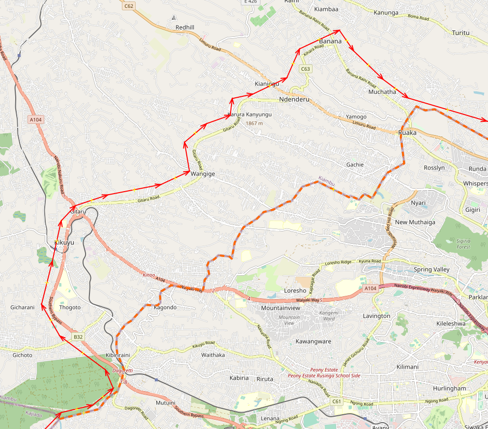
Nairobi, Kenya, is a thoroughly mapped area in OpenStreetMap. We chose to include more than just the Nairobi administrative boundary, because we think it is important to include the outer ring roads, as these are major transportation thoroughfares, and should be thought of as logistical parts of the metro area. This should allow our users to continuously capture imagery within the same region when circling around Nairobi. Nairobi is a good candidate metro area to expand by customer request.
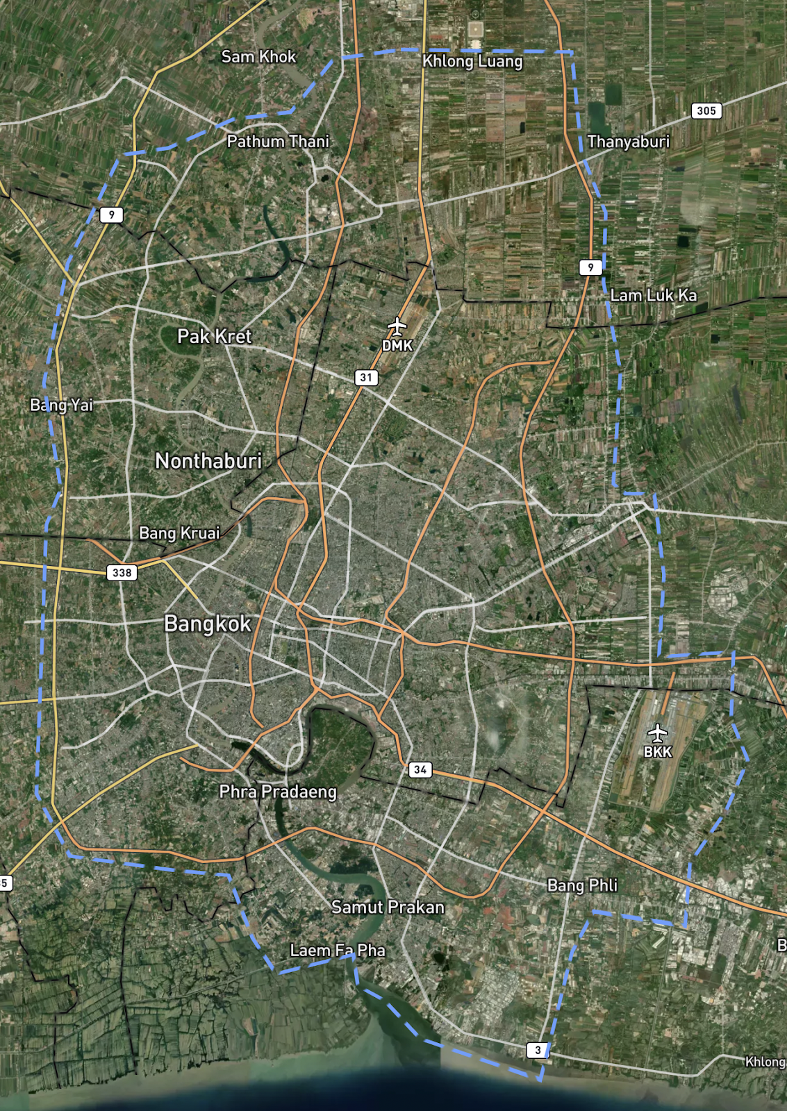
Other cities have less defined urban boundaries, and the developed land doesn’t have a clear break. Bangkok, Thailand, for example, does not have a clear metro boundary. Buildings and development become gradually less dense. With this city, we chose areas that were clearly less dense, and we made sure that the boundary was along a road to prevent cutting off a driver that is circling the metro area.
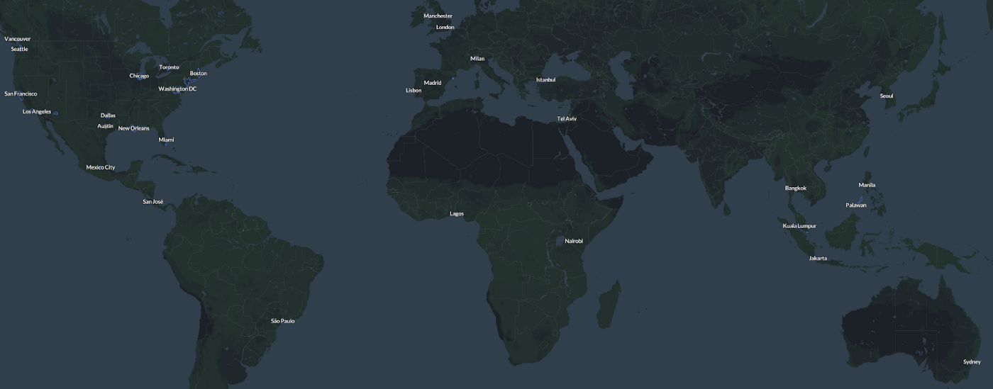
Hivemapper Mainnet Beta Metro Regions

What do you think about our proposed boundary for your metro region?
Your feedback is valuable to us and we’ll be sure to take it into account as we finalize the 35 metro region boundaries. Please share your feedback in the comments below.
Share Post


