
The Latest Buzz
Drive Smarter and Safer: Hivemapper’s Map AI Supercharges ADAS Systems

Hivemapper enhances ADAS capabilities, ensuring safer and more informed driving experiences in real-time conditions.
Advanced Driver Assistance Systems (ADAS) are designed to enhance driver safety, convenience, and comfort by providing assistance in various driving situations. They are not intended to replace the driver but rather to work alongside them to mitigate the risk of accidents and improve the overall driving experience. ADAS systems are considered Level 1 to Level 2+ and perform functions like adaptive cruise control, lane-keeping, self-parking, exiting highways, and emergency braking. Today, most ADAS systems are restricted to highways and major arterial roads.
The global ADAS market was estimated to be worth over USD 30 billion in 2022 and is projected to reach over USD 65 billion by 2030. This growth is driven by advances in technology, consumer demand for safety features, and EU government regulations requiring cars to know and follow the speed limit. Most ADAS products are subscriptions and a new and growing revenue source for car manufacturers. BlueCruise, Ford’s ADAS system, is still in its early days, with 225,000 ADAS-equipped cars and limited map coverage you can see here. BlueCruise has 150,000 customers paying $800 per year.
Like humans, ADAS systems compute driving paths through perception, interpretation, and decision-making. An ADAS system uses cameras, radars, GPS/GNSS sensors, and ultrasonic sensors to “see” its environment in real-time. It anticipates questions like: “Is the car in front of me slowing down?” or “Can I change lanes or is there a car in my blind spot?” But, these cameras and sensors have limited range and cannot make out the entire situation. Additionally, they can’t anticipate what’s coming up on the road ahead without a map.
Think of it this way: You can more easily navigate in your local city than the city you’re visiting because you created a mental map of your local city. In a city you’re visiting, you’ll see all the novel road signs but you’ll have a harder time interpreting them and making decisions. An ADAS system is like a tourist in every city, perceiving the different environments of San Francisco and Tokyo but struggling to interpret them and make decisions. That’s where maps come in — maps make interpretation and decision-making easier for ADAS systems. With a map, an ADAS system becomes like a local in every city.
While humans only need maps to navigate, ADAS-equipped cars need maps to drive. A map fills in critical information that an ADAS system needs to perceive beyond the range of its sensors. Here are some examples where an ADAS system will not perceive critical information:
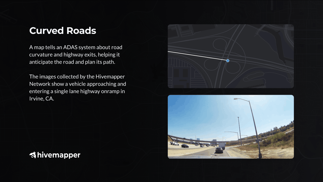
- Curved road / highway exit.
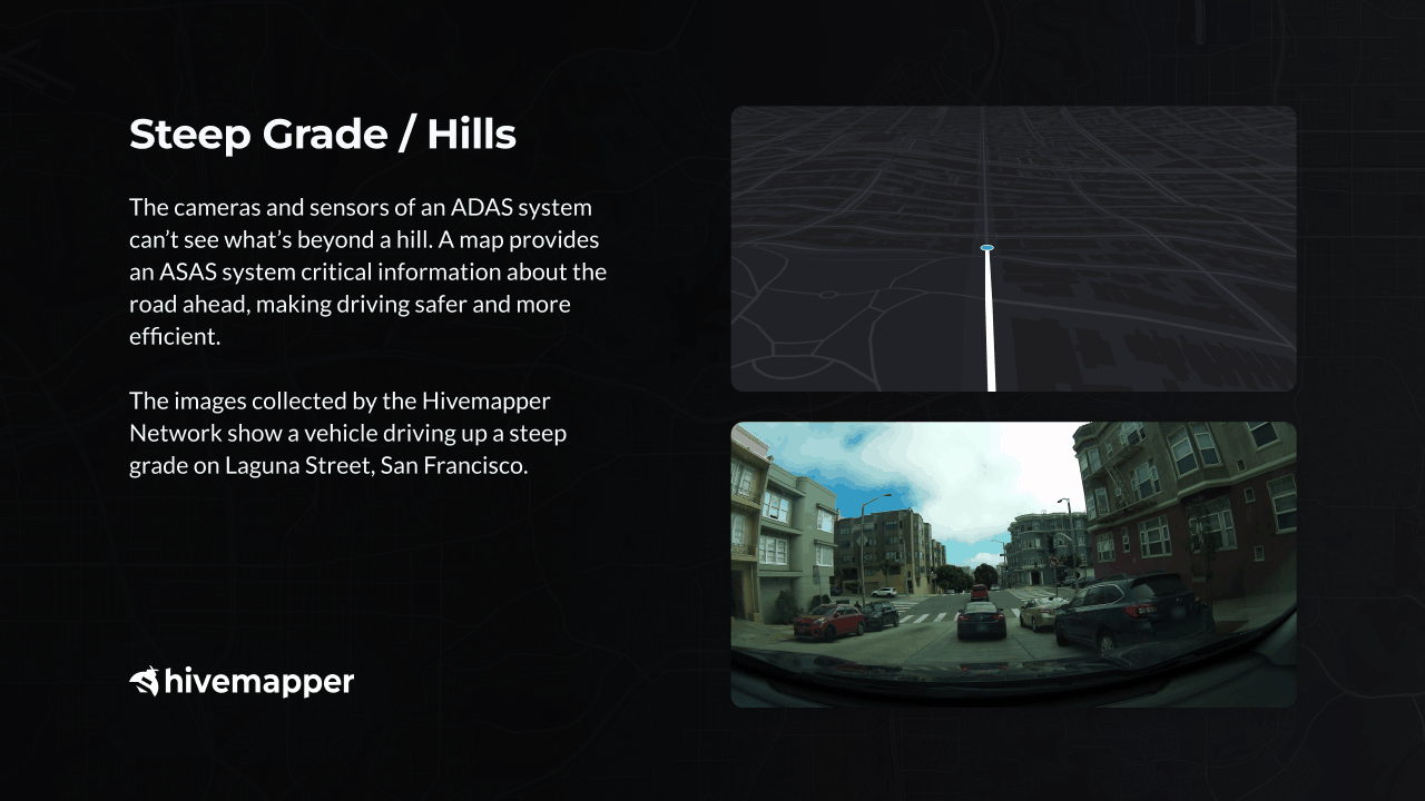
- Steep grade / hills.
- Complex road with multiple paths for drivers, bikes, and pedestrians.
- Poor weather conditions (heavy rain, snow, or fog).
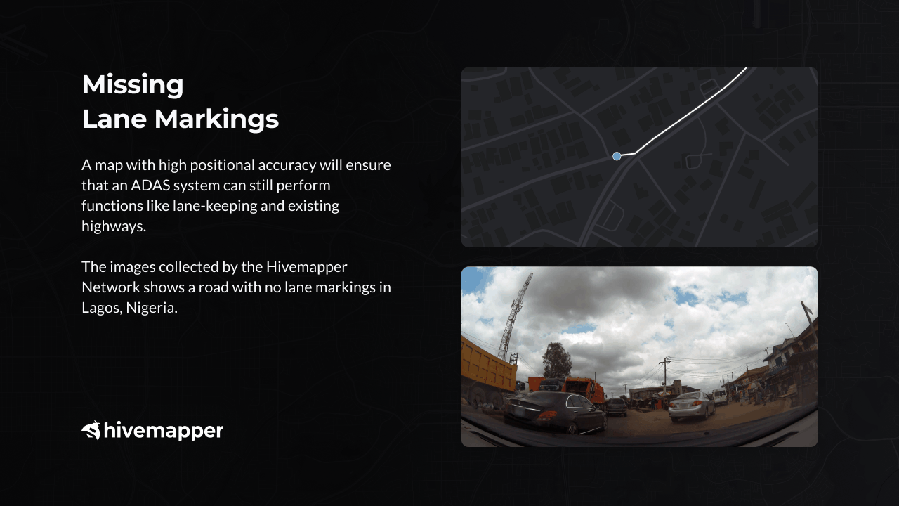
- Missing lane marking.
- Highway exit with multiple lanes.
- Highway exit closure.
- Construction — e.g., a drivable path reduced from 3 lanes to 1 lane.
Curved Road / Highway Exit. Imagine you are cruising down a highway. Your ADAS system is keeping a close eye on your surroundings using its sensors. As you approach an exit, the highway curves to the right just before the exit sign appears. This is when the ADAS system's reliance on a detailed map comes into play. The map already knows about the curve and the exit. Using this knowledge, the ADAS helps steer your vehicle smoothly through the bend, making sure you exit safely. This is a great example of how the ADAS system combines sensors and maps to make driving safer and more convenient.
Steep Grade / Hills. Imagine driving up a steep incline, like the hilly streets of Lisbon, Portugal. If you’re driving upward, you can’t see what’s beyond the hill. Similarly, cameras and sensors of an ADAS system can’t see upcoming road signs and intersections when driving up a steep hill. In the absence of a clear line of sight, a map holds critical information about what’s coming up ahead. With a map, your ADAS system can warn you about upcoming road signs and intersections and keep your journey smooth and safe.
Poor Weather Conditions. Driving the hilly and winding roads of San Francisco when they’re shrouded in the city’s signature fog is difficult even for the most experienced driver. As the thick fog obscures the road ahead, a map provides an ADAS system critical data about the city’s streets, road signs, and landmarks to drive safely.

Complex Road With Multiple Paths. Navigating through complex roads with multiple paths for drivers, bikes, and pedestrians in a city like Seoul, Korea, is demanding even for a local driver. A detailed map will help an ADAS system interpret this complex interplay of traffic and accurately identify the intended paths for each type of commuter.

Missing Lane Markings. Visualize a bustling metropolis like Lagos, Nigeria. When lane markings are missing, a map with high positional accuracy becomes indispensable. Using a map, an ADAS system can still perform functions like lane-keeping and exiting highways.
Historically, maps had one customer group — humans. Now, maps have two customer groups — humans and vehicles. As more vehicles get equipped with ADAS systems, more vehicles become consumers of maps.
ADAS systems rely on real-time perception of their surroundings, making the freshness and accuracy of maps essential for their effectiveness. The current maps available were primarily designed around 2005 when their primary users were humans, and they were not optimized to meet the real-time demands of ADAS systems. The challenge lies in the cost-intensive nature of mapping. Due to the significant financial resources required, the mapping industry is predominantly controlled by large corporations like Google. As a monopoly, Google faces less market pressure to enhance its map APIs or maintain competitive pricing.
Until now. Unlike Google��’s specialized Street View cars that cost $500,000 each, Hivemapper leverages the 1.4 billion vehicles that are already on the roads globally. The Hivemapper network “sees” the world through its purpose-built sensor — the Hivemapper Dashcam. The Hivemapper community has mapped 5 million unique kilometers of roads across more than 90 countries, representing more than 8% of the world’s roadways, in just eight months.
While this rate of coverage is impressive, Hivemapper’s main competitive advantage is its ability to continuously update its map. Hivemapper has cumulatively mapped 50 million total kilometers, consistently refreshing the map data for the most highly traveled roads and providing a reliable and continually updated data stream for our customers. Read more about how Hivemapper is outpacing Google here.
Hivemapper’s decentralized approach is more cost-effective than Google’s approach. Hivemapper collects images with its purpose-built sensor, the Hivemapper Dashcam. You can learn more about Hivemapper’s Map AI here. Additionally, unlike Google, Hivemapper rewards its contributors and protects their privacy. Read more about how Hivemapper safeguards the privacy of everyone who contributes here.
With dashcams as eyes, the Hivemapper network sees more places around the world with more frequency. While Google has 1 shot every 2 years, Hivemapper has more than 100 shots. Hivemapper’s high refresh rate provides the real-time insights an ADAS system needs to understand its surroundings and drive.
Hivemapper launched Bursts, a bounty feature for targeting mapping, in August. Map customers can incentivize fresh data for certain locations, whether it's a neighborhood or an entire town. This feature gives them the ability to decide how much this coverage is worth to them and create incentives for the community to deliver. Read more about Bursts here.
Hivemapper’s end-to-end map AI platform can supercharge your ADAS system with the following products:
- Street level Imagery to train your own models for ADAS
- Location change monitoring — monitor specific locations for changes e.g. highway exit closures, construction, etc.
- Map Features — correctly positioned objects such as speed limit signs, turn restriction signs, highway exit signs and more. to integrate into your map for ADAS
__
Follow us on X (Twitter) and join the community on Discord.
Share Post


