
The Latest Buzz
Building mapping data products on Hivemapper

Billions of people use maps each day, and millions of businesses from Uber to FedEx to BMW rely on maps. This post will focus on how Hivemapper is approaching building map APIs for businesses.
Hivemapper is a two-sided mapping network. One side builds the map, and the other side consumes the map. Since the launch of the network in November 2022, the Hivemapper community has started to grow and scale the map, building valuable and fresh map coverage. Mapping the world will not happen overnight. It’s a big and complex place. Yet, we are so encouraged by the exponential growth we’re seeing that it’s time to focus more on talking about the data products; high quality, frequently updated map data built on top of the mapping network, which businesses can then leverage in street-level navigation.
Think about it this way, the mapping network - governed by the Hivemapper Foundation - produces Lego blocks. Hivemapper Inc. assembles those Lego blocks into useful data products that businesses can easily consume and integrate into their products via map APIs.
For example, if you show up at a car manufacturer and say I have incredible street-level imagery for 20M road km, they won’t see an easy way to use that information. But if you say I have updated speed limit information for 20M road km that is kept fresh every month, that is interesting and relevant to them. They know how to consume that data, and have a built-in ROI for this kind of data making it easy for them to rationalize spending on it.
There are 5-7 million businesses and organizations that use maps for a wide variety of use cases. Hivemapper is primarily focused on building data products for street-level navigation. Why?
- Navigation requires incredibly fresh and accurate information — road construction impacts logistic deliveries and the safety of an ADAS (advanced driver assistance) system.
- Navigation represents the vast majority of map usage on a global scale. Billions of people and millions of businesses use maps to safely and efficiently transport people and goods from point A to B. If you are part of moving people and goods, you enable vast sums of economic activity which makes the data products easier to monetize.
- Navigation is changing rapidly due to autonomy, new modes of transport (EV and e-bikes), urbanization, and climate. These changes require fresher and better maps.
How we build map data products
Before getting into the exact map APIs we are building for businesses, let’s first discuss how we transform raw collected data into useful and relevant data.
The Hivemapper Dashcam collects high resolution imagery as well as accurate GPS coordinates, speed, and acceleration. But in order to provide customers with meaningful and accessible data, the raw imagery needs to be processed using machine learning and human quality assurance to extract higher-value object data (e.g. speed signs, road construction, traffic signs, etc.)
If you look around while driving, you’ll notice an endless number of useful data objects that could be extracted from images. For-sale signs outside houses might be valuable to real estate developers. Billboards might be valuable to advertising companies. The length of the line of trucks waiting at a port might be useful to commodities traders. Realistically, we cannot focus on all these objects even though they represent many valuable use cases. We have decided to focus on data objects that enhance and support navigational use cases for now. With that in mind, Hivemapper is focusing its efforts on producing the three categories described below:
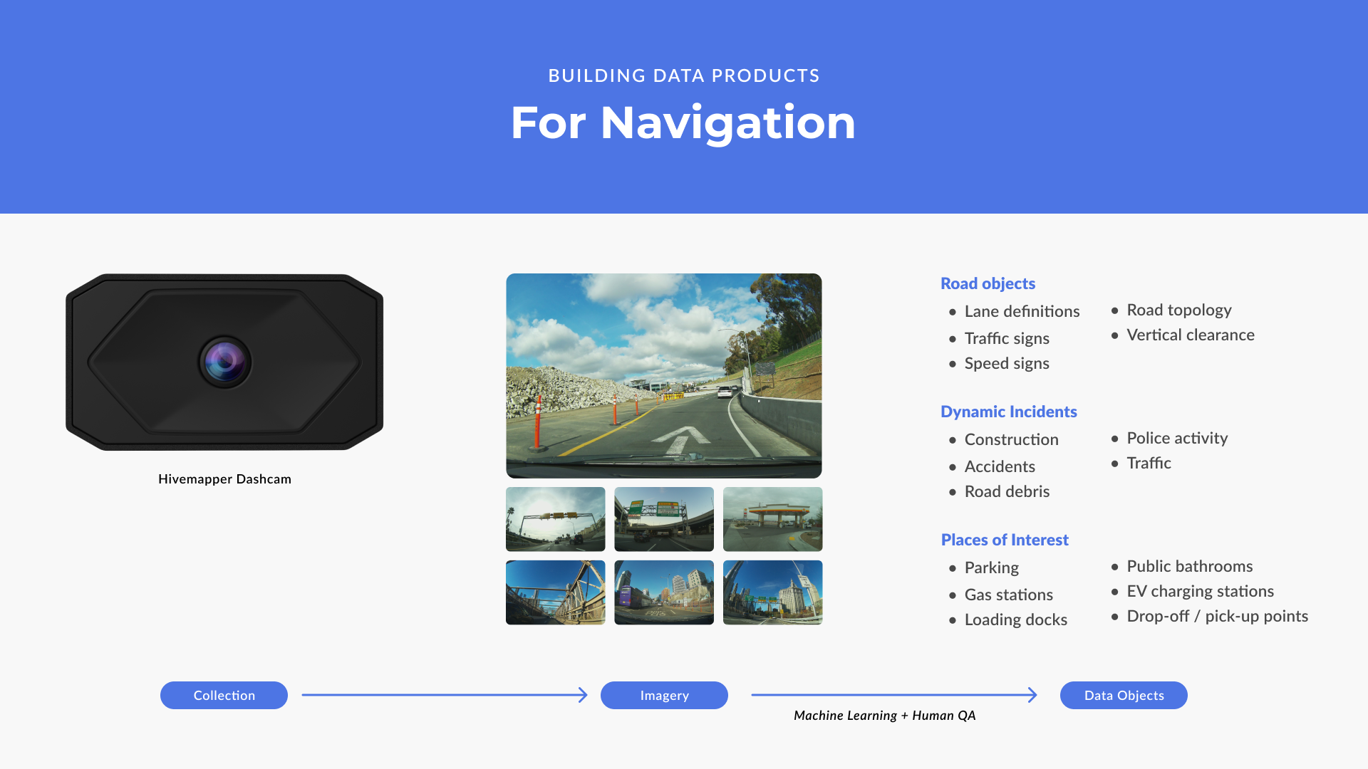
The objects (e.g. traffic signs, road debris) represented are examples in each category. For each, there will be many more objects than shown in this graphic.
Places of interest will be limited to ones that directly enhance the driver experience, such as parking lots, EV charging stations, loading docks, and even public bathrooms. Across 60 million global road km the data objects we care about change at varying frequencies:
- Hourly change - construction closes lanes, road debris, dynamic toll prices, etc.
- Weekly change - gas prices, venue closes drop-off/pickup location
- Annual change - speed signs, traffic signs, etc.*
*On average, about 15% of the signs, lanes, etc. you see will change each year - per TomTom.
Customers and use cases
Since we are squarely focused on navigational use cases, the question that often follows goes something like this: “Is Hivemapper building a turn-by-turn consumer navigation app to compete with Google Maps?” No. We are focused on the millions of businesses that use maps to run their business.
Even if you never use the Google Maps website or app, you are probably interacting with Google Maps data many times per day. If you hail a ride through Uber, you are using Google Maps. If you get directions to a restaurant through Yelp, you are using Google Maps. If you use the navigation service on your Tesla, you are using Google Maps.
Millions of businesses use the Google Maps API. Google has exploited its dominant market position by raising prices for its map APIs by more than 1,800% since 2018. We constantly hear from customers that have been forced to throttle usage of Google Maps APIs due to cost.
However, with Hivemapper we’ll have millions of cars constantly collecting mapping data. Hivemapper’s API is easily implemented, affordable, and already used by businesses.
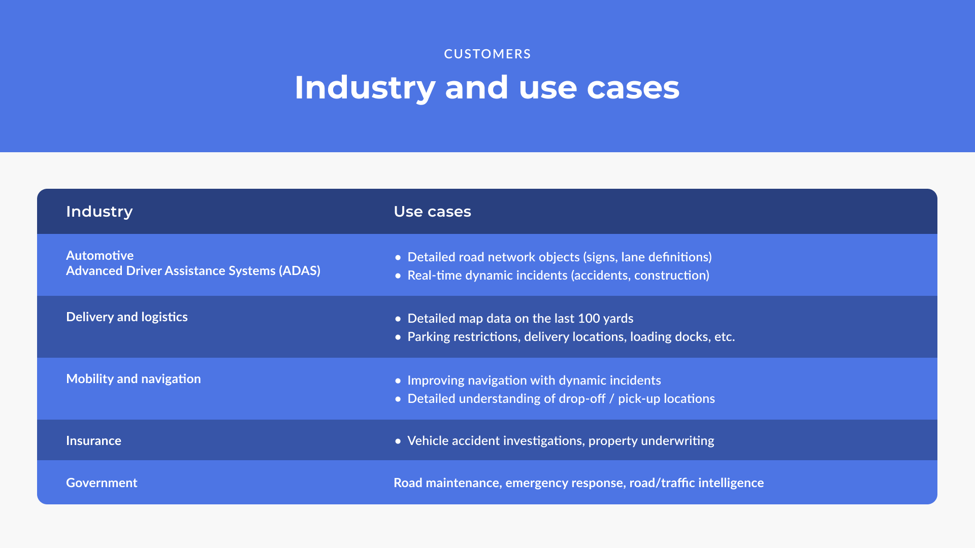
Let’s explore some of these use cases starting with automotive ADAS (advanced driver assistance systems), these are systems like Blue Cruise sold and deployed today across a range of vehicles. They perform L2 and L3 driving automation. This level of autonomy means the vehicle can autonomously merge on and off highways and maintain a lane while driving on highways or major roads. Additionally, some ADAS systems can now navigate major arterial roads in urban settings.
While they all use camera based perception systems and advanced positioning technology, we have seen that their operational capabilities and domain improve with a detailed and up to date map.
Let’s look at some specific examples where a map is critical to an ADAS system.
- There are many parts of the world where the lane markings have been worn down and the perception system is unable to see them. Having detailed lane definitions of the roads ensures that the ADAS remains engaged and active throughout.
- Often times the ADAS camera system is blinded by the sun, think back to a winter day when the sun is directly in your eyes. During these moments having a precise and accurate map of the road topology is critical to its safety.
- Understanding the road curvature and bank angle is critical to automatically adjusting the speed to operate safely through these parts of the road.
- Understanding which traffic light controls which lanes
- Understanding whether roads are one-way or bi-directional
Today’s maps were primarily built for consumers. Think, people navigating to a new restaurant or to the airport using turn-by-turn directions. When doing delivery and logistics the problems are different — they often need to navigate to the loading docks, understand toll prices as that impacts cost of delivery, they need to consider whether the delivery vehicle will have enough vertical clearance and turn clearance to safely make the delivery, and have to be aware of road conditions. The delivery vehicle is a valuable asset, the more wear and tear on the vehicle the faster it depreciates.
Hivemapper Map APIs
Over the coming years, Hivemapper will build a full suite of map APIs data products that businesses can use within their products. This year, we are focused on building three map APIs shown below.
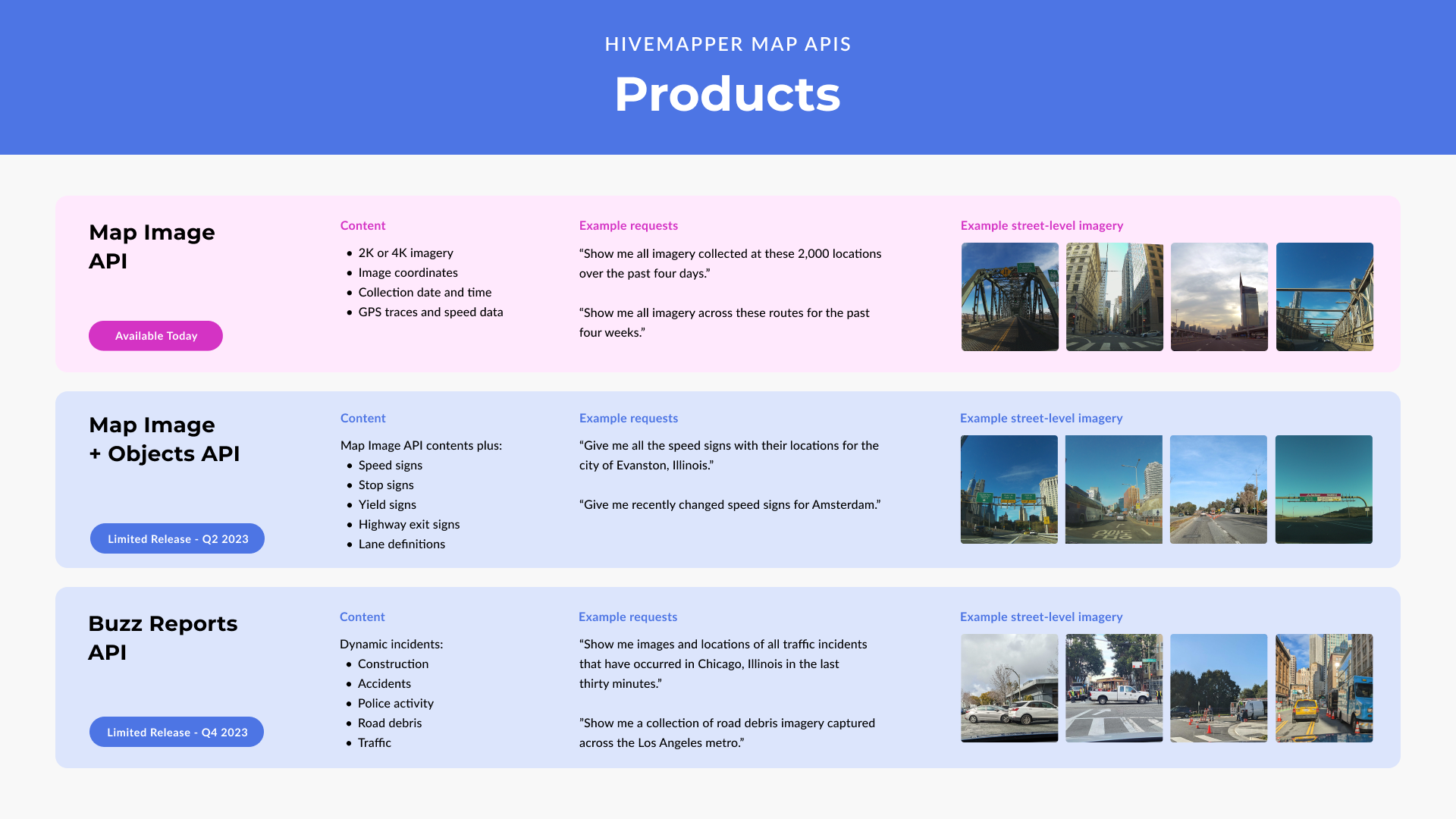
Some frequently asked questions about the current set of map APIs shown above.
Will Hivemapper build additional map APIs?
Absolutely. We see a full suite of map APIs including a new kind of turn-by-turn directions, visual positioning, and more. Some businesses will use one or two, while others will use the full suite.
Can other organizations build their own map API data products?
Yes. The mapping network is permissionless, meaning any organization can build their own products on top of the mapping network’s data. For example, if an organization wants to build a location intelligence product to help property insurance companies underwrite risk more effectively, they will have the same access to mapping network data that Hivemapper Inc. will have.
What will be the pricing for the Map Image + Object API and the Buzz Reports API?
The pricing for the Map Image API is available and very cost effective. We have not yet published the pricing for the Map Image & Object API or the Buzz Reports API. However, given they are producing higher value data they will be priced accordingly.
Will the Buzz Report API be available globally?
No. It will first reach usefulness in key regions with very high density. The Los Angeles and Seoul metro regions are clearly headed towards high levels of density where they will begin to provide useful and real-time reports of incidents from construction to road debris to police activity.
Share Post


